Designing for Commuter Trust:
Solving Public Transport in Emerging Markets.
Other than driving and car navigation, the biggest unsolved problem in Maps today is public transport. Over a billion commuters navigate unpredictable bus lines, informal transit, and spotty connectivity. Here is how we transform messy, fragmented telemetry into rock-solid commuter trust.
Target Scale
1 Billion+
Daily emerging market riders
Interaction Focus
Multimodal
Metro ➔ Auto/Ojek ➔ Bus
Low-Bandwidth
Sub-150ms
Fallback rendering on 2G/3G
Commuter State
Zero Panic
Probabilistic ETA confidence
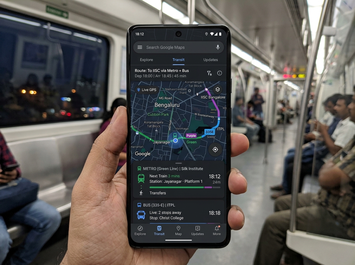
Multimodal Commuter Trust Simulator.
Simulate real transit corridors in Bengaluru, Jakarta, and São Paulo. Toggle real-world stress conditions to see how the UI maintains clarity and eliminates commuter panic.
Namma Metro (Purple Line)
Platform screen doors active. High frequency dispatch every 4 mins.
3 UX Inventions for Emerging Market Transit.
Standard Silicon Valley transit design assumes clean GTFS feeds, mild weather, and structured transfers. Here are 3 breakthrough interaction patterns designed specifically for the chaos of emerging markets.
Probabilistic Arrival Bands Instead of Fake Precision.
In Bengaluru or São Paulo, buses travel under 2km concrete flyovers where GPS signals scatter (multipath reflection). Traditional Google Maps says "Arriving in 3 mins" and freezes there for 10 minutes when the bus is stuck in gridlock. This destroys user trust.
My Solution: When GPS packet latency exceeds 90 seconds, the UI dynamically switches from a pinpoint minute to a Confidence Arrival Window (e.g. 14–19 mins) with an honest confidence score and historical dispatch data. Commuters always know reality.
GPS beacon was obscured under Silk Board Flyover 3 mins ago. Timing calculated using historical dispatch cadence + real-time upstream corridor speed.
Why Driving Navigation UX Fails in Public Transit.
User controls vehicle steering, speed, departure timing, and intermediate stops.
Zero physical control. Commuter is entirely dependent on external dispatch, platform gates, and physical connections.
Traffic bottlenecks, highway toll booths, and missing highway interchanges.
Missed connections, platform confusion, overcrowded standing conditions, and last-mile safety.
Mounted phone display, hands-free turn audio prompts, predictable posture.
Held in one hand on a vibrating bus, rapid 3-second glances under harsh sunlight while gripping a handrail.
Single continuous vehicle route from point A to B without intermediate modal switches.
Complex physical transitions: Walk ➔ Station Gate ➔ Rail ➔ Handoff ➔ Feeder Auto ➔ Bus ➔ Destination Walk.
Continuous high-frequency GPS pings from the user's personal smartphone.
Heterogeneous, noisy, intermittent GPS beacons, multipath reflection under overpasses, and unmapped informal routes.
| Dimension | Driving & Turn-by-Turn | Public Transport & Multimodal |
|---|---|---|
| User Agency | User controls vehicle steering, speed, departure timing, and intermediate stops. | Zero physical control. Commuter is entirely dependent on external dispatch, platform gates, and physical connections. |
| Primary Cognitive Anxiety | Traffic bottlenecks, highway toll booths, and missing highway interchanges. | Missed connections, platform confusion, overcrowded standing conditions, and last-mile safety. |
| Interaction Ergonomics | Mounted phone display, hands-free turn audio prompts, predictable posture. | Held in one hand on a vibrating bus, rapid 3-second glances under harsh sunlight while gripping a handrail. |
| Multimodal Handoffs | Single continuous vehicle route from point A to B without intermediate modal switches. | Complex physical transitions: Walk ➔ Station Gate ➔ Rail ➔ Handoff ➔ Feeder Auto ➔ Bus ➔ Destination Walk. |
| Data Reliability | Continuous high-frequency GPS pings from the user's personal smartphone. | Heterogeneous, noisy, intermittent GPS beacons, multipath reflection under overpasses, and unmapped informal routes. |
Answering the 4 Core Pillars of Emerging Markets Transit.
Designing public transport in emerging markets requires a fundamentally different mindset than Western car navigation. Here is how my background as a Design Engineer solves these 4 distinct challenges.
Complex Systems & Messy Data
Public transport feeds in Bengaluru, Jakarta, or São Paulo are rarely clean GTFS-RT APIs. They are a chaotic mix of missing scheduled departures, GPS multipath reflection off concrete overpasses, and unmapped informal routes (auto stands, angkots, lotações).
In ICEYE Missions OS and Kuick Delivery, I engineered state machines that decouple erratic raw telemetry from UI presentation. Instead of showing erratic jumping vehicle pins, we interpolate positions and replace false precision with probabilistic arrival confidence.
The Realities of Emerging Markets
Emerging markets do not behave alike. A commuter in Bengaluru relies on prepaid auto-rickshaws for the first mile; a Jakarta rider depends on elevated TransJakarta BRT corridors; a São Paulo commuter navigates peripheral micro-bus networks. Common denominators: extreme ambient sunlight, low-spec hardware, and expensive data.
Designing with tactical high-contrast tokens, extreme outdoor legibility, and zero reliance on heavy WebGL map tiles for core timing answers. The split-screen progress layout ensures users know their next move even with battery saver active.
An Exceptionally High Craft Bar
A moving bus with heavy vibrations is an unforgiving test environment. Tiny buttons and subtle grey text fail immediately. Craft at Google scale means ergonomic 48px+ tap targets, WCAG 2.1 AA color contrast, fluid micro-interactions, and instant sub-100ms response times.
As a hybrid Designer & Next.js/React engineer, I don’t just hand off Figma mockups. I test live code prototypes directly on physical budget devices under direct sunlight, ensuring token variables, font leading, and gestures perform without lag.
Sharp Product Thinking & Commuter Trust
When a commuter is rushing to work, uncertainty causes panic: "Will the connecting auto-rickshaw be there?" "Is the bus overcrowded?" "Should I take the metro or call a cab?" Product thinking is anticipating this cognitive anxiety and proactively answering it.
Transparent communication: If live GPS is temporarily lost, tell the user honestly ("GPS lost 4m ago • Scheduled arrival in 6–8m") rather than freezing. Designing for trust means making the interface honest and resilient under failure states.
Explore More Telemetry & Logistics Systems
See how these principles are applied in live production code across satellite mission tasking and omnichannel hyper-local logistics.